
Manyara Region: Northern Tanzania
Manyara Region is one of Tanzania’s most geographically and culturally diverse regions, situated in the northern part of the country. Named after the iconic soda lake that lies partly within its borders, the region serves as a critical gateway to Tanzania’s celebrated Northern Safari Circuit — the chain of protected areas that includes Serengeti National Park, Ngorongoro Crater, Lake Manyara National Park, and Tarangire National Park.
The region was carved out of the former Arusha Region in 2002 as part of the Tanzanian government’s decentralization reforms, and since then it has grown into a vibrant administrative and economic hub. Its administrative capital, Babati, sits at the foot of the Rift Valley escarpment and acts as the commercial heart of the region, linking highland farming communities to lowland pastoral plains.
Manyara’s landscape is shaped by the dramatic topography of the East African Rift System. The floor of the Great Rift Valley cuts through the western portion of the region, creating alkaline lakes, vast open plains, and steep escarpments. Above the valley floor, highland massifs rise to volcanic peaks, the most impressive of which is Mount Hanang — Tanzania’s fourth-highest mountain at 2,962 metres. This varied terrain supports an extraordinary range of ecosystems, from acacia woodland and savannah to montane forest and swamp.

For travellers, Manyara Region offers an experience that blends world-class wildlife viewing with rich cultural encounters and off-the-beaten-track adventure. For residents and investors, it offers fertile agricultural land, expanding infrastructure, and a young, growing economy. This guide presents a detailed account of the region’s geography, history, people, economy, wildlife, and tourism landscape.
| Region | Manyara |
| Location | Northern Tanzania, East Africa |
| Capital | Babati |
| Area | Approx. 45,820 km² |
| Population | Approx. 1.5 million (2022 est.) |
| Major Languages | Swahili (official), English, Iraqw, Maasai, Barbaig |
| Major Ethnic Groups | Iraqw, Maasai, Barbaig, Chagga, Arab communities |
| Elevation Range | 550 m (lake shore) to 2,962 m (Mount Hanang) |
| Primary Economy | Agriculture, Tourism, Pastoralism, Small-scale trade |
| Key Attractions | Lake Manyara NP, Tarangire NP, Ngorongoro (adjacent), Mount Hanang |
Geography and Physical Environment
Location and Boundaries
Manyara Region occupies approximately 45,820 square kilometres in northern Tanzania. It is bordered to the north and north-east by Arusha Region, to the east by Kilimanjaro Region, to the south-east by Tanga Region, to the south by Dodoma Region, to the south-west by Singida Region, and to the west by Shinyanga and Simiyu Regions. The region’s position at the crossroads of highland, rift valley, and semi-arid zones gives it a uniquely varied physical character.
The Great Rift Valley
One of the most defining geographic features of Manyara Region is its position within the East African Rift System. The Gregory Rift — the eastern branch of the Great Rift Valley — cuts directly through the region from north to south, creating a landscape of escarpments, volcanoes, fault scarps, and soda lakes. The western escarpment rises sharply above Lake Manyara, providing spectacular viewpoints and a microclimate that supports lush groundwater forest at its base.
The Rift Valley floor in this region sits at elevations between 950 and 1,100 metres, while the escarpment walls rise to over 2,000 metres. This dramatic elevation contrast drives rainfall patterns, vegetation zones, and wildlife habitats across very short horizontal distances.
Lakes and Water Bodies
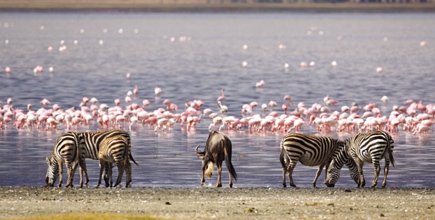
Manyara Region is blessed with several significant water bodies, the most famous being Lake Manyara itself. This shallow, alkaline soda lake covers approximately 230 square kilometres during the wet season and is fringed by groundwater forest, acacia woodland, and open floodplains. It is renowned for its populations of flamingoes and is a key feature of Lake Manyara National Park.
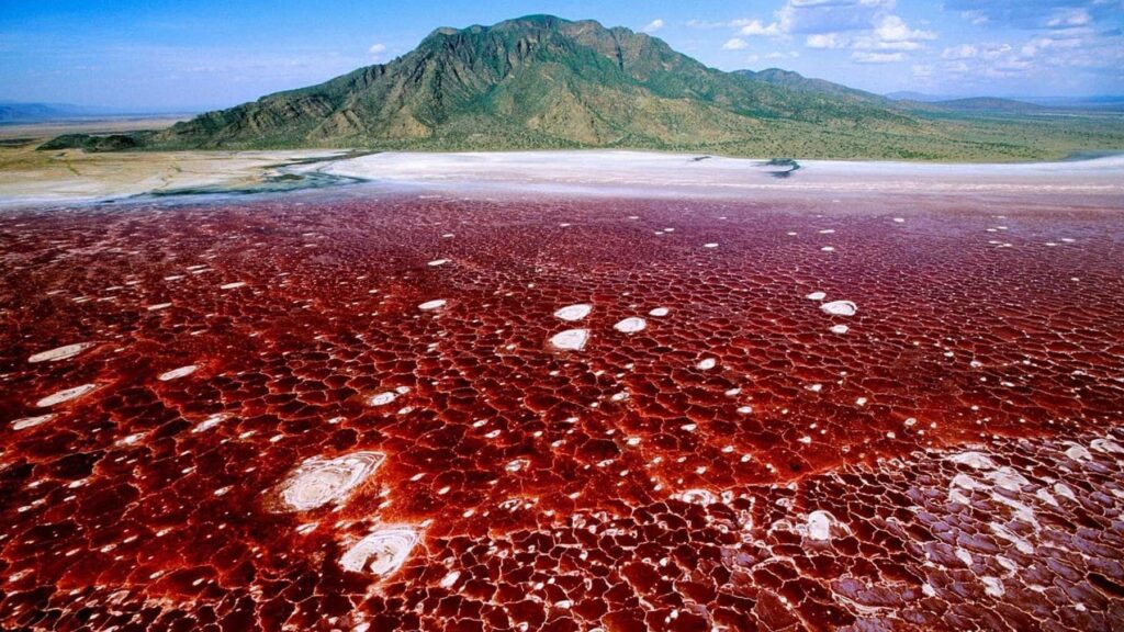
Further north, Lake Natron — one of Africa’s most extreme environments — straddles the border between Manyara Region and Arusha Region. Its hyper-alkaline waters, fed by volcanic springs and the Ewaso Ng’iro River, support the world’s largest breeding colony of lesser flamingoes. The lake’s caustic conditions, with a pH approaching 10.5 and surface temperatures reaching 60°C, make it lethal to most animals but uniquely suited to these resilient birds.
Lake Burunge and Lake Duluti, while smaller, provide freshwater habitats that support diverse birdlife and offer recreational opportunities for local communities and visitors alike.
Mountains and Highlands
The region’s highland areas are dominated by Mount Hanang (2,962 m), an extinct stratovolcano located in the Hanang District. Hanang is Tanzania’s fourth-highest mountain and is considered sacred by the Barbaig (Datoga) pastoralist community who inhabit its foothills. The mountain is increasingly visited by trekkers seeking a less-crowded alternative to Kilimanjaro.
The Mbulu Highlands, rising to the west of Lake Manyara, form a vast upland plateau. These fertile highlands receive relatively reliable rainfall and are extensively cultivated by the Iraqw people, known for their sophisticated terracing and water-harvesting practices.
Climate
Manyara Region experiences a bimodal rainfall pattern typical of East Africa’s northern zone. The long rains (masika) fall between March and May, while the short rains (vuli) arrive in November and December. Annual rainfall varies considerably across the region:
- Mbulu Highlands and escarpment zone: 700 – 1,100 mm per year
- Rift Valley floor and lowlands: 400 – 600 mm per year
- Semi-arid west (Hanang, Mbulu Lowlands): 300 – 500 mm per year
Temperatures are moderated by altitude in the highlands (mean 16–22°C) and hotter in the valley floor and lowland zones (mean 24–30°C). The dry season from June to October is the most comfortable period for travel and wildlife watching.
History
Pre-Colonial Era
The lands that constitute present-day Manyara Region have been inhabited for millennia. Archaeological evidence from sites across the Rift Valley floor suggests the presence of early hominids and Stone Age peoples. The region sits along ancient migration routes that connected East Africa’s interior highlands to the coast, and later served as corridors for the Bantu migrations that reshaped the continent’s demographic landscape.
The Iraqw (also known as Mbulu) people are believed to be among the earliest inhabitants of the Mbulu Highlands, with origins traced by linguists and oral historians to the Cushitic-speaking peoples of north-east Africa. Their sophisticated agricultural practices, including underground irrigation channels called mengua, allowed them to sustain large communities on the highlands long before colonial contact.
The Maasai, arriving from the north as part of their southward migration during the 17th and 18th centuries, came to dominate the lower plains of the Rift Valley floor. Their pastoralist traditions and cattle-centred culture shaped the ecology of the grasslands they occupied.
The Slave and Ivory Trade
During the 18th and 19th centuries, Arab and Swahili traders extended their caravan routes deep into the interior of East Africa, passing through the territories of present-day Manyara Region. These caravans carried ivory and enslaved people from the interior to the coast, where they were shipped to the Arabian Peninsula, the Persian Gulf, and beyond. The disruption caused by these raids devastated many communities and fundamentally altered the social fabric of the region.
German Colonial Period (1885–1919)
Following the Berlin Conference of 1884–85, the region fell under the control of German East Africa (Deutsch-Ostafrika). The Germans established administrative posts and sought to exploit the agricultural potential of the highlands. They encountered fierce resistance from local communities, most notably the Maji Maji Rebellion of 1905–07 — one of the largest anti-colonial uprisings in African history — which, while centred further south, had reverberations throughout German East Africa.
German colonial administrators introduced coffee and sisal cultivation to parts of the region and began building roads and administrative infrastructure. Lutheran and Catholic missionaries arrived during this period, establishing schools and churches that became centres of literacy and community organisation.
British Mandate and Independence
Following Germany’s defeat in World War I, Tanganyika became a League of Nations Mandate administered by Britain. Under indirect rule, the British relied on local chiefs and headmen to administer communities, reinforcing some traditional power structures while undermining others. Agricultural taxation and forced labour policies created hardship but also, paradoxically, accelerated the monetisation of local economies.
Tanzania gained independence on 9 December 1961 under Julius Nyerere’s TANU (Tanganyika African National Union). The region underwent significant changes during the Ujamaa (African Socialism) era of the 1960s and 70s, when the government collectivised farming and forced population resettlement into communal villages. While Ujamaa disrupted traditional land use patterns, it also expanded access to education, healthcare, and clean water in previously remote areas.
People and Culture
Ethnic Diversity
Manyara Region is home to one of Tanzania’s most diverse ethnic mosaics. The following groups are among the most significant:
The Iraqw (Mbulu)
The Iraqw are the most numerous group in Manyara Region and have inhabited the Mbulu Highlands for centuries. They speak a Cushitic language (Iraqw) and are renowned agriculturalists who have developed sophisticated land management techniques adapted to the steep highland terrain. Iraqw society is traditionally organised around clan lineages, with elders playing a central role in conflict resolution and resource management.
The Maasai
Semi-nomadic pastoralists, the Maasai are synonymous with East Africa’s open savannahs. In Manyara Region, Maasai communities are concentrated on the plains around Lake Manyara, Tarangire, and the lower Rift Valley. They keep large herds of cattle, sheep, and goats, moving seasonally in search of water and pasture. Maasai cultural identity is expressed through elaborate beadwork, distinctive red shúkà (cloth wraps), and age-grade ceremonies including the warrior (moran) initiation.

The Barbaig (Datoga)
The Barbaig are one of Tanzania’s lesser-known pastoralist groups, living primarily in the area around Mount Hanang and the Basotu plains. They are renowned metalworkers and warriors, with a history of conflict with neighbouring Maasai and Iraqw communities. The Barbaig maintain a strong oral tradition and spiritual connection to Mount Hanang, which they regard as the home of their ancestral spirits.
Other Communities
Smaller communities include the Nyaturu, Gorowa, Alagwa, Arab traders, and recent in-migrants from across Tanzania who have settled in towns like Babati and Mbulu, adding further layers to the region’s cultural tapestry.
Languages
Swahili is the official language of Tanzania and the lingua franca of Manyara Region. English is used in government, education (secondary and tertiary), and formal business. Indigenous languages including Iraqw, Maasai (Maa), Barbaig, and several others remain in everyday use within their respective communities, and language preservation is an important cultural priority for many groups.
Religion
Christianity and Islam are the two dominant religions in Manyara Region. Christianity — in its Lutheran, Catholic, and Pentecostal forms — is particularly strong in the highland areas where missionary activity was concentrated during the colonial period. Islam is prevalent in the lowland trading towns and among communities with historical ties to the coastal Swahili culture. Traditional spiritual beliefs and ancestor veneration continue to play an important role alongside formal religion, particularly among the Barbaig and older Maasai communities.
Arts, Music, and Traditions
The region’s cultural life is rich with music, dance, and craft. Maasai adornment — especially the intricate beadwork created by women — is internationally recognised. Iraqw folk music features distinctive string instruments and communal singing traditions tied to agricultural cycles. The Barbaig are known for their engraved leather garments and iron jewellery. Markets and festivals provide regular opportunities for cultural exchange and display of traditional arts.
Administrative Structure
Manyara Region is divided into seven administrative districts:
- Babati Urban District — home to the regional capital, Babati town
- Babati Rural District — surrounding agricultural hinterland
- Hanang District — centred on Mount Hanang and the Basotu plains
- Kiteto District — semi-arid lowlands bordering Dodoma and Kilimanjaro Regions
- Mbulu District — the highland heartland of the Iraqw people
- Mbulu Urban District — including the growing town of Mbulu
- Simanjiro District — vast semi-arid plains shared with parts of Arusha Region
The regional capital, Babati, is located approximately 170 km south of Arusha city along the B1 highway. It serves as the centre of regional government, commerce, and transport. While smaller than Arusha or Moshi, Babati has grown steadily since the region’s creation and now boasts a reasonable range of hotels, markets, banks, and transport links.
Economy
Agriculture
Agriculture is the backbone of Manyara Region’s economy, employing the majority of the population and generating the bulk of household incomes. The Mbulu Highlands are among Tanzania’s most productive farming areas, yielding maize, wheat, barley, sorghum, beans, and vegetables. Pyrethrum — a natural insecticide derived from chrysanthemum flowers — is an important cash crop in the cooler highland areas. Coffee cultivation, while on a smaller scale than in Kilimanjaro Region, is present in the more humid highland zones.
Pastoral farming remains central to the livelihoods of Maasai, Barbaig, and other communities in the drier lowlands and plains. Cattle herding is not merely an economic activity but a cultural institution, with herd size serving as a measure of wealth and social standing.
Tourism
Tourism is Manyara Region’s most rapidly growing economic sector. The region sits at the heart of Tanzania’s Northern Safari Circuit, and hundreds of thousands of visitors pass through or overnight in the region each year. The key driver is wildlife tourism, anchored by Lake Manyara National Park and Tarangire National Park. Revenue from tourism supports both direct employment (guides, lodge staff, drivers) and indirect livelihoods in hospitality, crafts, agriculture, and transport.
Community-based tourism initiatives, including cultural villages, guided walks with Maasai communities, and agro-tourism experiences in Iraqw farmland, are expanding and offering visitors more authentic, off-circuit encounters.
Mining and Natural Resources
The region has modest but significant mining activity. Gemstone mining — particularly tanzanite, sapphire, and ruby — occurs in parts of the region, though on a smaller scale than in Kilimanjaro’s Simanjiro corridor. Limestone quarrying supplies local construction and cement industries. There is increasing interest in the geothermal energy potential of the Rift Valley zone, which could become a significant future resource.
Trade and Commerce
Babati serves as the main commercial hub of the region, with weekly markets drawing buyers and sellers from across northern Tanzania. Cross-border trade with Kenya is facilitated by the road network through Arusha. The region’s location on the B1 highway — a major trunk road connecting Dar es Salaam to Arusha — means it benefits from through-traffic and a steady flow of goods.
Wildlife and Protected Areas
Lake Manyara National Park
Lake Manyara National Park covers approximately 325 square kilometres, of which roughly two-thirds is the lake itself. Established in 1960 and later designated a UNESCO Biosphere Reserve, the park is celebrated for its extraordinary density and diversity of wildlife packed into a relatively compact area.
The park’s groundwater forest — fed by springs seeping from the Rift Valley escarpment — is one of the most impressive in East Africa, supporting troops of olive baboons, blue monkeys, red-tailed monkeys, and forest birds. The acacia woodland and floodplains beyond support massive elephant herds, buffaloes, giraffes, zebras, wildebeest, and hippos. The park is particularly famous for its lion population, which has developed the extraordinary habit of resting and sleeping in trees — a behaviour rarely observed elsewhere in Africa and thought to be an adaptation to biting flies or a way to gain a vantage point over the flat terrain.
Birdlife in the park is exceptional, with over 400 species recorded. During the rains, the lake shore hosts hundreds of thousands of lesser and greater flamingoes, along with pelicans, storks, herons, and shorebirds. The park is reachable within a 1.5-hour drive from Arusha and is commonly visited as a day trip or overnight excursion.
Tarangire National Park
Tarangire National Park, covering approximately 2,850 square kilometres, is one of Tanzania’s most underrated wildlife destinations. Located in the southern part of Manyara Region, the park takes its name from the Tarangire River, which flows year-round through the park and serves as a critical dry-season water source for wildlife.
During the dry season (June–October), Tarangire hosts one of Africa’s greatest wildlife concentrations as thousands of animals converge on the river. Elephant populations here are among the highest density in Africa — herds of over 100 individuals are commonly seen. The park is also home to large numbers of buffaloes, zebras, wildebeest, gazelles, impalas, giraffes, elands, oryx, and gerenuk. Predators include lions, leopards, cheetahs, African wild dogs, and spotted hyenas.
Tarangire is renowned for its magnificent baobab trees — ancient giants that dot the landscape and give the park a primordial, otherworldly atmosphere. The park also has significant swamp ecosystems that support large waterbird colonies.
Lake Natron
While administratively shared between Manyara and Arusha Regions, Lake Natron is an extraordinary natural spectacle most commonly accessed via the Manyara Region. The lake is the primary breeding site for the world’s East African population of lesser flamingoes (Phoeniconaias minor). Each year, up to 2.5 million flamingoes breed on the caustic mudflats of the lake — one of the greatest wildlife spectacles on Earth.
The area around Lake Natron also offers spectacular hiking, including the challenging ascent of Ol Doinyo Lengai (2,962 m), an active volcano revered by the Maasai as the ‘Mountain of God.’ Natron has increasingly become a destination for adventurous travellers seeking something well off the main safari circuit.
Wildlife Corridors and Conservation
One of the critical functions of Manyara Region’s landscape is its role as a wildlife corridor linking Tarangire to the broader ecosystem that includes Serengeti, Ngorongoro, and the Kenyan national parks. Elephants and other wide-ranging species move seasonally through community lands between these protected areas. Conservation organisations, including the African Wildlife Foundation and Tanzania Land Conservation Trust, work with local communities to protect these corridors through conservation easements, community conservancies, and wildlife-friendly land-use practices.
Tourism and Travel
Getting There
Manyara Region is well-connected to Tanzania’s main transport network:
- By Air: Kilimanjaro International Airport (KIA), near Arusha, is the main international gateway, served by major airlines. Lake Manyara Airstrip receives scheduled charter flights from Arusha, Serengeti, and other bush airstrips.
- By Road: The B1 highway connects Arusha to Babati (approx. 170 km, 2.5–3 hours). Dar es Salaam is approximately 680 km to the south. The road network within the region varies from tarmac highways to graded dirt tracks.
- By Bus: Regular bus services connect Babati, Mbulu, and other regional centres to Arusha and Dar es Salaam.
Accommodation
Manyara Region offers a wide spectrum of accommodation, from ultra-luxury safari lodges to budget guesthouses:
- Luxury and Premium: Lodges and camps in and around Lake Manyara National Park and Tarangire National Park offer world-class facilities, often set in stunning bush landscapes. Operators such as &Beyond, Elewana, and African Bush Camps maintain properties here.
- Mid-Range: Comfortable lodges and tented camps near the parks provide good quality facilities at moderate prices. The Ngorongoro Conservation Area, adjacent to the region’s northern border, also has several mid-range options.
- Budget: Babati, Mbulu, and other towns have simple guesthouses and small hotels suitable for travellers on tight budgets or those exploring the region independently.
Activities
Beyond classic game drives, Manyara Region offers an increasingly diverse range of tourism experiences:
- Game Drives: Morning and afternoon game drives in Lake Manyara and Tarangire National Parks, with professional guides.
- Night Game Drives: Permitted in Tarangire, offering the chance to see nocturnal species including bush babies, porcupines, and lion hunts.
- Walking Safaris: Offered by several operators in areas adjacent to the parks, allowing close encounters with vegetation, insects, tracks, and smaller animals rarely seen from a vehicle.
- Canoe Safaris on Lake Manyara: Paddling on the lake at dawn offers extraordinary birding and hippo encounters.
- Mount Hanang Trekking: A two-day trek to the summit of Tanzania’s fourth-highest mountain, through Barbaig pastoral lands.
- Cultural Tourism: Visits to Iraqw farms and traditional villages, Maasai bomas, and Barbaig homesteads with guided cultural interpreters.
- Cycling: Mountain biking trails are being developed in the Mbulu Highlands for adventurous visitors.
- Flamingo Watching at Lake Natron: Guided walks to the flamingo colonies and the shoreline of Lake Natron.
Best Time to Visit
The optimal time to visit Manyara Region depends on the activity:
- Wildlife Viewing: June to October (dry season) is best for seeing large concentrations of wildlife around water sources in Tarangire. Animals are easier to spot in the sparse dry-season vegetation.
- Birding: November to April (wet season) attracts migratory birds and flamingo gatherings on Lake Manyara.
- Photography: The green wet-season landscape (March–May, November–December) offers lush backdrops and dramatic skies for landscape photography.
- Trekking: June to October for Mount Hanang, when trails are dry and conditions clear.
Infrastructure and Services
Roads and Transport
The B1 highway, running south from Arusha through Babati and on towards Dodoma and Dar es Salaam, is the region’s primary transport artery and is mostly tarmacked. Secondary roads connecting district headquarters are generally graded gravel and are passable year-round in normal conditions, though some become challenging during heavy rains. Four-wheel-drive vehicles are recommended for travel in the more remote areas of Simanjiro, Hanang, and Kiteto Districts.
Energy
Manyara Region is partly served by the national electricity grid, with Babati and larger towns connected. Rural electrification has been expanding through both grid extension and off-grid solar programmes. Given the significant geothermal potential of the Rift Valley, there is long-term scope for renewable energy development in the region.
Healthcare
The region has a network of public health facilities including Babati District Hospital and smaller health centres and dispensaries across the districts. Private clinics operate in the main towns. For serious medical emergencies, patients are typically evacuated to Arusha or, in extreme cases, to Nairobi. Travellers are strongly advised to take out comprehensive travel insurance with medical evacuation cover.
Education
Primary and secondary schools are present in all districts, and the region has seen significant improvements in enrolment rates over recent decades. Veta (Vocational Education and Training Authority) centres provide technical training, and higher education is accessed primarily through institutions in Arusha and Dar es Salaam.
Challenges and Opportunities
Human–Wildlife Conflict
As wildlife populations grow and human settlement expands into traditional wildlife corridors, conflicts between people and animals have become a significant challenge. Elephants raiding crops, lions preying on livestock, and the loss of life to hippos and buffaloes are recurring problems in communities adjacent to national parks. Community-based conservation models that share tourism revenue with local villages have shown promise in reducing conflict and incentivising coexistence.
Land Use and Tenure
Competing land use claims — between agro-pastoralists, subsistence farmers, wildlife conservancies, and tourism developers — create tension in several parts of the region. The formalisation of village land certificates and the establishment of clear Wildlife Management Areas (WMAs) are important but contested mechanisms for resolving these conflicts.
Climate Change
Changing rainfall patterns, prolonged droughts, and increasingly erratic weather are placing pressure on both agriculture and pastoral livelihoods. Lake Manyara’s water levels have fluctuated dramatically in recent decades, affecting both wildlife habitats and the tourist experience. Adaptation strategies — including drought-resistant crops, water harvesting, and diversified income sources — are critical for community resilience.
Opportunities for Growth
Despite these challenges, Manyara Region has considerable development potential. Tourism diversification — developing new products beyond the standard park circuit — could spread economic benefits more widely and relieve pressure on the most-visited areas. Agricultural commercialisation, with better access to markets, storage, and processing, could significantly increase farm incomes. Investment in renewable energy, particularly solar and geothermal, could transform the region’s energy landscape and support industrial development.
Practical Information for Visitors
The following practical information is provided for travellers planning to visit Manyara Region:
Visa and Entry
Most nationalities require a visa to enter Tanzania. The Tanzania e-Visa can be obtained online before travel (www.immigration.go.tz). East African Community citizens (Kenya, Uganda, Rwanda, Burundi, South Sudan, DRC) have specific arrangements. Visa on arrival is available at major international airports.
Health Precautions
Malaria is endemic in the lower-lying areas of the region. Prophylactics, insect repellent, and protective clothing are strongly recommended. Yellow fever vaccination may be required depending on your country of origin. Typhoid and hepatitis A vaccinations are advisable. Drink only bottled or boiled water and avoid ice of uncertain origin.
Currency and Banking
Tanzania’s currency is the Tanzanian Shilling (TZS). ATMs are available in Babati and Mbulu towns. Major hotels and lodges accept credit cards, but cash is essential for smaller towns, markets, and rural areas. US dollars are widely accepted for tourist services and park fees.
Communications
Mobile phone coverage (Vodacom, Airtel, Tigo, TTCL) is available in most towns and along major roads, but can be patchy or absent in remote areas. 4G data is accessible in Babati and the main towns. WiFi is offered at most mid-range and luxury lodges.
Safety
Manyara Region is generally safe for tourists. Standard precautions apply: do not display valuables publicly, use reputable transport operators, and inform your accommodation of your plans when travelling to remote areas. Wildlife areas should always be navigated with a qualified guide.
Conclusion
Manyara Region stands as one of Tanzania’s most compelling destinations — a place where the drama of the East African Rift Valley, the spectacle of world-class wildlife, and the richness of deeply rooted human cultures converge in a single, accessible landscape. From the flamingo-pink shores of Lake Manyara to the towering silhouette of Mount Hanang, from the ancient traditions of the Iraqw and Barbaig to the ultramodern tented camps of Tarangire, the region rewards visitors with experiences that are both thrilling and deeply human.
As Tanzania continues to develop its tourism industry and expand economic opportunity beyond the main circuits, Manyara Region is well positioned to play an increasingly important role. With thoughtful investment in conservation, community empowerment, and sustainable infrastructure, the region can ensure that its extraordinary natural and cultural heritage remains intact for generations to come — while delivering tangible benefits to the people who call it home.