Mount Kilimanjaro Map and Kilimanjaro Routes
Mount Kilimanjaro Map and Kilimanjaro Routes: The Mount Kilimanjaro Map and Kilimanjaro Routes will assist you during your trekking expedition to the summit of Mount Kilimanjaro, which rises to 5,895 meters (19,340 feet), making it the highest peak in Africa and the tallest freestanding mountain globally. This Kilimanjaro map guide will identify every path on Mount Kilimanjaro and provide guidance on the hiking routes, camps, and map of Kilimanjaro routes.
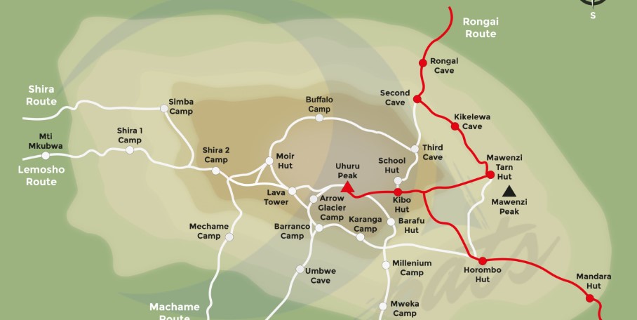
Map of Mount Kilimanjaro Routes
The Mount Kilimanjaro Map and Routes delineates each climbing route along with designated camps where climbers will rest overnight until they reach Uhuru Peak. This map identifies all climbing routes, including the Machame, Marangu, Lemosho, Rongai, Northern Circuit, and Umbwe routes.
The Mount Kilimanjaro Map and Routes delineates each path along with the designated camps where climbers will rest overnight until they reach the summit of Uhuru Peak on Kilimanjaro.
Mount Kilimanjaro Marangu Route Map
The Marangu route on Mount Kilimanjaro is among the more congested and opulent paths, owing to its hut accommodations along the mountain. This route extends over 72 kilometers to the summit, commencing at an elevation of 1,860 meters (6,100 feet) and culminating at Uhuru Peak at 5,895 meters (19,341 feet). The Marangu pathway is often known as “Coca-Cola” because of the comfortable huts situated along the path.
The Marangu route on Mount Kilimanjaro is among the more congested and opulent paths, owing to its hut accommodations along the mountain. This route extends over 72 kilometers to the summit, commencing at an elevation of 1,860 meters (6,100 feet) and culminating at Uhuru Peak at 5,895 meters (19,341 feet). The Marangu pathway is often known as “Coca-Cola” because of the comfortable huts situated along the path.
Mandara Hut (2,700 meters / 8,858 feet): Your Kilimanjaro expedition commences here. Situated within the verdant rainforest, Mandara Hut offers a picturesque commencement to your expedition.
Horombo Hut (3,720 meters / 12,205 feet): Following a day’s trek, you will arrive at Horombo Hut. This camp has breathtaking vistas of the Mawenzi and Kibo peaks and imparts the initial experience of elevated altitude.
Kibo Hut (4,700 meters / 15,420 feet): The last campsite prior to the summit attempt, Kibo Hut is aesthetically pleasing but devoid of the verdancy found in the lower camps. This is where you will repose prior to your early morning ascent to Uhuru Peak.
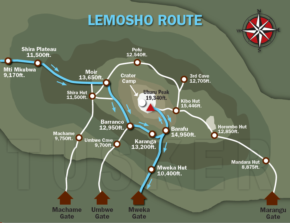
Map of Mount Kilimanjaro and Routes – Lemosho Route
The Lemosho route is a picturesque path on Mount Kilimanjaro, extending about 70 km from the summit, with an 85%-90% success rate for reaching Uhuru Peak. The Lemosho route has recently gained popularity among hikers, rivaling the Machame and Marangu routes, owing to its scenic vistas and diverse terrain. The route camps are exceptionally daring; below are the Lemosho route camps designated by the Mount Kilimanjaro Map and Routes:
Londorossi Gate (2,100 meters / 6,890 feet): Although not a campsite, this serves as the access point to the Lemosho Route. You will finalize the documentation and commence your hike at this location.
Mti Mkubwa Camp (2,820 meters / 9,250 feet): Your expedition commences in the rainforest, with the initial camp situated at Mti Mkubwa, enveloped by towering trees.
Shira 1 Camp (3,505 meters / 11,500 feet): Your path briefly intersects with the Machame Route, and you will camp at Shira 1, encircled by the expansive Shira Plateau.
Shira 2 Camp (3,840 meters / 12,600 feet): An elevated camp situated on the Shira Plateau, with breathtaking vistas of the surrounding terrain.
Barranco Camp (3,960 meters / 12,995 feet): You will rejoin the Machame Route in Barranco Camp for one night, capitalizing on its superior acclimatization prospects.
Karanga Camp (4,035 meters / 13,238 feet): An essential waypoint prior to the summit ascent, Karanga Camp is situated on a rocky ridge, offering expansive vistas.
Barafu Camp (4,680 meters / 15,357 feet): The last camp prior to the summit attempt, Barafu Camp is desolate and windy. This is where you will repose prior to the final challenge.
Mount Kilimanjaro Rongai Route Map
The Rongai path, as seen on the Mount Kilimanjaro Map and Routes, is the sole approach to Mount Kilimanjaro from the north. This route spans about 73 kilometers to the summit and commences at an elevation of 1,950 meters.
Rongai Gate (1,950 meters / 6,400 feet): Your Rongai expedition commences at the gate, where you will initiate your ascent via a less frequented route.
Simba Camp (2,625 meters / 8,611 feet): This is the initial camp on the Rongai Route, which provides verdant surroundings and a tranquil commencement to your expedition.
Second Cave (3,450 meters / 11,319 feet): As you rise, the terrain transforms, and you will overnight at Second Cave, enveloped by heath and moorland.
Kikelewa Camp (3,600 meters / 11,811 feet): This camp offers superior acclimatization prospects as you ready yourself for elevated elevations.
Mawenzi Tarn Camp (4,330 meters / 14,206 feet): Located adjacent to the magnificent Mawenzi Peak, this camp is a remarkable site that provides breathtaking vistas.
Kibo Hut (4,700 meters / 15,420 feet): The last campsite prior to the summit ascent, Kibo Hut is strikingly attractive yet devoid of the verdancy characteristic of the lower camps. This is where you will repose prior to your early morning ascent to Uhuru Peak.
| Route | Duration (Days) | Difficulty |
|---|---|---|
| Marangu | 5–6 | Easy |
| Machame | 6–7 | Moderate |
| Rongai | 5–6 | Easy to Moderate |
| Lemosho | 7–8 | Moderate |
| Umbwe | 5–6 | Challenging |
| Shira | 6–7 | Moderate |
| Northern Circuit | 8–9 | Moderate to Easy |
| Mweka (Descent Only) | — | Steep |
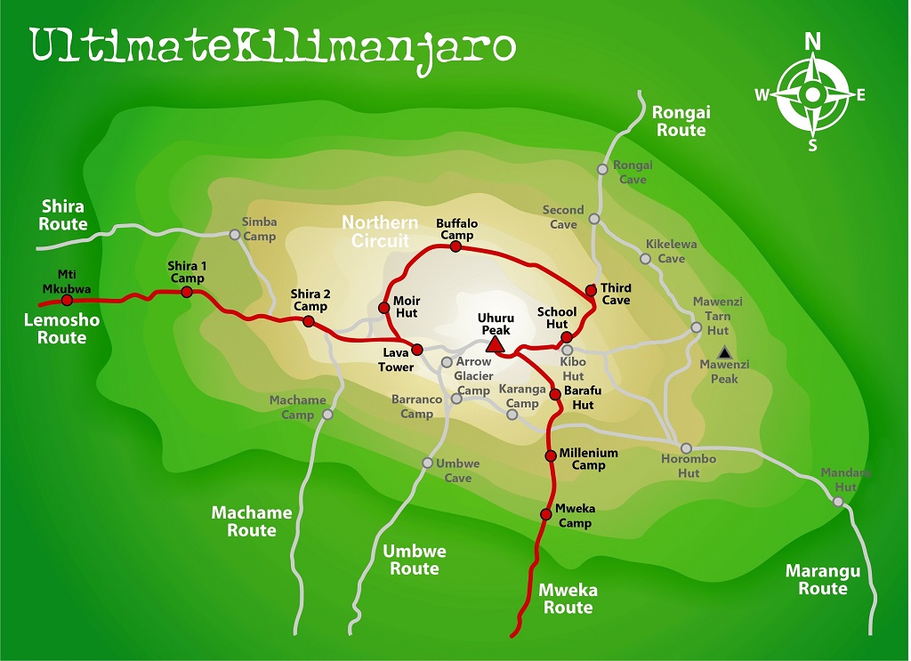
Mount Kilimanjaro Northern circuit Route Map
Londorossi Gate (2,100 meters / 6,890 feet): Commencing your expedition at Londorossi Gate is akin to initiating the Lemosho Route.
Mti Mkubwa Camp (2,820 meters / 9,250 feet): Your initial campsite is situated in the rainforest, providing a tranquil commencement to your expedition.
Shira 1 Camp (3,505 meters / 11,500 feet): Temporarily joining the Machame Route, you will camp at Shira 1, which offers extensive vistas of the Shira Plateau.
Shira 2 Camp (3,840 meters / 12,600 feet): Situated on the Shira Plateau, this camp offers stunning views of the surrounding terrain.
Moir Hut (4,200 meters / 13,780 feet): Moir Hut provides seclusion and a chance for acclimatization, serving as a tranquil waypoint prior to embarking on the Northern Circuit.
Buffalo Camp (4,020 meters / 13,189 feet): Upon embarking on the Northern Circuit, Buffalo Camp provides an atmosphere of seclusion and serenity.
Third Cave Camp (3,870 meters / 12,697 feet): A tranquil campsite located in heath and moorland, offering a serene night’s repose.
School Hut (4,750 meters / 15,584 feet): The final campsite prior to the summit attempt, School Hut well earns its name as a venue for understanding the forthcoming problems and readying oneself for the ascent.
Common Inquiries Regarding Maps of Mount Kilimanjaro
Where can I obtain comprehensive maps of the climbing routes on Mount Kilimanjaro?
Comprehensive maps of Mount Kilimanjaro’s climbing routes can be found on multiple websites, including Jaynevy Tours, which offers a detailed map illustrating all seven ascending routes and the Mweka descent path.
What are the primary climbing routes on Mount Kilimanjaro?
The primary climbing routes on Mount Kilimanjaro include Marangu, Machame, Lemosho, Shira, Rongai, Northern Circuit, and Umbwe. Every route differs in complexity, landscape, and length.
Is there a map indicating the starting places of each Kilimanjaro route?
Indeed, charts are accessible that delineate the origins of each Kilimanjaro path. For instance, Jaynevy Tours offers a Google Earth map delineating the primary roads and their origins.
May I acquire a physical map of Mount Kilimanjaro prior to my expedition?
Physical maps of Mount Kilimanjaro are available for purchase at bookstores that focus on travel or outdoor pursuits, as well as through internet vendors. It is important to obtain a map before to your expedition for enhanced preparedness.
Are interactive maps accessible for planning my ascent of Kilimanjaro?
Numerous websites provide interactive maps to facilitate the planning of your Kilimanjaro ascent. These maps offer comprehensive details regarding routes, campsites, and elevation profiles.