
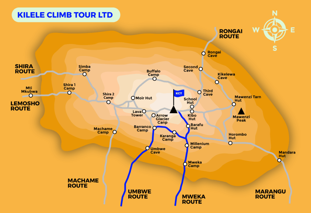
Umbwe Route
The Umbwe route is among the shortest paths to the Southern Glaciers and the Western Breach, and it is regarded as the most arduous and challenging route on Mount Kilimanjaro. The rapid pace of the ascent and its steep gradient render acclimation exceedingly challenging.
The Umbwe Route is the pathway for climbers seeking an authentic ascent difficulty. It is an infrequently traversed path that can be somewhat challenging, yet immensely gratifying. This route is ideal for anyone seeking to challenge themselves on the slopes of Mount Kilimanjaro, away from the crowds prevalent on the more popular trails.
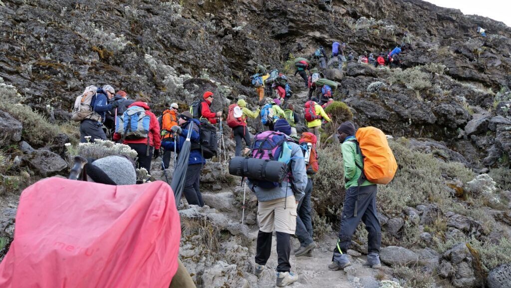
The Umbwe trail, however non-technical, has steep ascents and necessitates trekkers to go over rocks and tree roots at various intervals. The path is recognized as the most arduous and direct ascent of Kilimanjaro, incorporating multiple exposed ridges that are unsuitable for the timid.
The endurance and physical condition of hikers may be challenged en route, making it most suitable for seasoned mountain trekkers seeking an arduous experience.
The steep and straight nature of the Umbwe path results in a lower success percentage compared to other routes.
Trekkers are advised to be in optimal physical condition for this ascent, as the initial days involve a continuous uphill walk, unlike other routes that provide gradual ascents or undulating paths to facilitate acclimatization.
Nonetheless, the arduous challenge of traversing the Umbwe Route is compensated by the breathtaking vistas. Occasionally, trekkers encounter breathtaking panoramas on both the left and right while ascending the trail.
The initial segment of this trail perhaps offers the finest vistas of the mountain, second only to the summit itself. Umbwe is also one of the most tranquil paths to ascend Mount Kilimanjaro. Due to its reputation as a challenging ascent, few individuals traverse this trail, resulting in its preservation and relative pristine condition.
This provides trekkers with the sensation of solitude on the mountain until the path converges with the Machame trail around Barranco Camp a few days into the climb. Subsequently, it traverses the well-known Southern Circuit beneath the Southern Ice Field before ascending towards the summit from Barafu Camp. The descent, like most Kilimanjaro ascents, occurs via the Mweka Route.
If you seek the finest vistas when ascending Mount Kilimanjaro and relish challenging yourself in the environment, the Umbwe route will offer you all that you desire and more. This is the most authentic mountaineering adventure available on Kilimanjaro.
Climbing Kilimanjaro provides the Umbwe route as a 6 or 7 day option for both group and private ascents. The seven-day option incorporates an acclimatization day on the third day at Barranco Camp.
Overview of the 6-Day Umbwe Route Itinerary
Commencing at Umbwe Gate, proceeding to the summit, and concluding at Mweka Gate.
ASCEND MT KILIMANJARO – UMBWE ROUTE – 6 DAYS DAY 1: UMBWE GATE TO UMBWE CAVE CAMP
Elevation: 1600m to 2900m, Distance: 11km, Duration: 6 hours, Habitat: Montane Forest.
We shall register at Umbwe Park Gate before to commencing our walk. The narrow, meandering trail ascends through the rainforest and along the Umbwe River. The initial night’s encampment is at Umbwe Cave Camp, situated at around 2,900 meters elevation.
DAY 2: UMBWE CAMP TO BARRANCO CAMP
Elevation: 2940m to 3970m, Distance: 6km, Duration: 4-5 hours, Habitat: Montane Forest.
We go from the camp, and shortly thereafter, the forest concludes. The imposing wall of the Western Breach materializes and vanishes as the afternoon mists ascend the Great Barranco. We shall encamp at Barranco camp this evening.
DAY 3: BARRANCO CAMP TO KARANGA CAMP
Elevation (m): 3950 m to 3930 m, Distance: 7 km. Duration of Hike: 4 hours, Ecosystem: Alpine Desert.
Today commences with a brief yet enjoyable scramble to the summit of the Great Barranco Wall. We thereafter navigate across scree to the Karanga Valley (3930m), situated beneath the icefalls of the Heim, Kersten, and Decken Glaciers. We will spend the night in Karanga campground.
DAY 4: KARANGA CAMP TO BARAFU CAMP
Elevation (m): 3930 to 4600, Distance: 6 km Duration of Hike: 3 hours, Environment: Alpine Desert.
We depart from the Karanga campsite to reach the intersection that connects with the Mweka descending trail. We proceed to the Barafu Hut from this point. You have now finished the Southern Circuit, which provides perspectives of the summit from several angles. At the campsite, we can recuperate, savor dinner, and ready ourselves for the summit day. The two summits of Mawenzi and Kibo are distinctly visible from this location.
DAY 5: BARAFU CAMP TO SUMMIT TO MWEKA HUT
Elevation (m): 4600 m to 5895 m (and down to 3100 m). Distance: 7 km ascent / 23 km descent, Duration: 6-8 hours ascent / 7-8 hours descent. Habitat: Rocky debris and glaciated peak.
You will be awakened at 23:30 with a brief serving of tea and biscuits. We commence our ascent to the top situated between the Rebman and Ratzel glaciers. We will go in a north-westerly direction and rise through substantial scree towards Stella Point on the crater rim. This segment of the walk is the most psychologically and physically demanding. At Stella Point (5732m), we will pause briefly to recuperate and be rewarded with an extraordinary sunrise, contingent upon favorable weather conditions. At Uhuru Peak (5895m), we would have attained the apex of Mount Kilimanjaro and the African continent. Temperatures can be extremely low at night at these altitudes, although they will be somewhat warm by the conclusion of the hiking day. We descend from the summit to the Mweka Hut campsite, stopping at Barafu for lunch. Trekking poles are essential for navigating the loose gravel descent to Mweka Camp (3100m). In the evening, we will partake in our final dinner on the mountain followed by a deserved rest.
DAY 6: MWEKA CAMP TO HOTEL
Elevation: 3100m to 1800m, Distance: 8 km, Duration: 3-4 hours. Habitat: Montane Forest.
We will depart after breakfast, descending to the Mweka Park Gate to get your summit credentials. At lower altitudes, conditions may be damp and muddy. Gaiters and trekking poles will be beneficial. Shorts and t-shirts will be appropriate (retain rain gear and warmer attire readily available).
Common inquiries
The following questions and answers pertain specifically to the Umbwe Route.
What is the level of difficulty of the Umbwe Route?
The Umbwe route is among the shortest paths to the Southern Glaciers and the Western Breach, and it is the most arduous route on Mt. Kilimanjaro. The Umbwe path, accessed from the south, is a brief, steep, and direct ascent. It is likely the most picturesque, non-technical path on Kilimanjaro. The endeavor is arduous, chiefly owing to the rapid elevation gain, although the benefits are abundant.
This route lacks the requisite stages for acclimatization due to the rapid ascent to high altitude. Despite the minimal traffic on this route, the probability of success remains modest. A commendable level of fitness is strongly advised.
What is the length of the Umbwe Route and the duration of the trek?
The precise trekking distance for the Umber Route is 53 kilometers or 32 miles. The minimum duration for the Umbwe Route is 5 days, characterized by brief ascents and demanding hiking days. Including the arrival and departure days, the total is 9 or 10. Given that it is regarded as one of the shortest and steepest paths on the mountain, it is highly advisable to be thoroughly prepared and acclimatized to enhance your chances of success.
What is the success rate for summiting via the Umbwe Route?
The Umbwe Route is among the shortest paths to ascend Kilimanjaro, although it offers a limited opportunity for acclimatization due to its steep gradient and the duration spent on the summit. Although official statistics are lacking, the mean success rate among all operators is 70%. Our summit success rate for the Umbwe Route exceeds 90%!
How is the scenery along the Umbwe Route?
The initial two days of the Umbwe Route trek traverse tree plantations and subsequently a lush rainforest, before advancing into the precipitous Western Breach and Arrow’s Glacier path, culminating in a scramble to the Reutsch Crater (5,800 meters), where trekkers overnight adjacent to one of Kilimanjaro’s last remaining glaciers, the Furtwangler Glacier.
From Crater Camp, one may embark on an optional one-hour climb to Reusch Crater or explore the vicinity of Furtwangler Glacier. Reusch Crater is an impressive spectacle. The structure is nearly round, with the ash pit measuring 400 feet (120 m) in depth and 1,300 feet (400 m) in width. This is hardly observed by travelers.
What is the best time for trekking the Umbwe Route?
The optimal period for trekking the Umbwe Route is from July to September, since the weather is most consistent and the likelihood of rain is diminished. Consequently, because to its proximity to the equator, the peak may be ascended at any time during the year. April and May constitute the rainy season; hence, this period is best circumvented.