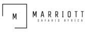
Mount Baker
Mount Baker, in conjunction with Mount Stanley and Mount Speke, forms a triangular configuration that encompasses the upper Bujuku Valley. Klaus Thymann’s expedition in 2020 confirmed the lack of glaciers on Mount Baker and Mount Speke. Thymann employed analogous images to illustrate that two of Africa’s five glaciated peaks have been eradicated.
Essential information Regarding Mount Baker
It is the sixth highest summit in Africa, reaching an elevation of 4,844 meters (15,892 feet). It creates a triangular formation with Mount Stanley and Mount Speke, spanning the upper Bujuku Valley. Mount Stanley is the nearest mountain, situated 2.26 kilometers (1.40 miles) to the west. The mountains are situated in an area referred to as “The Mountains of the Moon.”
Mount Baker, akin to several summits in the Ruwenzori Range, features multiple jagged peaks along a ridge. Edward Peak represents the apex. The ridge line of Mount Baker was first ascended in January 1906 by Austrian mountaineer Rudolf Grauer, accompanied by British missionaries H. E. Maddox and H. W. Tegart.
An English expedition, directed by Alexander F. R. Wollaston, A. B. Wosnam, and M. Carruthers, arrived at the identical rocky location between February and April of that year. The apex of Mount Baker was successfully reached in June by an expedition led by the Duke of Abruzzi, who also ascended all summits of the five largest mountains in the Rwenzori range.
The Bakonjo, an indigenous group in western Uganda, refer to the mountain as “Kiyanja.” In June 1891, Franz Stuhlmann observed the mountain on his expedition into the Ruwenzori and referred to it as either “Semper” or “Ngemwimbi.” The summit was named after Samuel Baker, a 19th-century British explorer who was the first European to discover and visit Lake Albert, located immediately northeast of the Ruwenzori Mountains, in 1864. He reported observing “huge mountainous masses in the distance, to the south of Lake Albert.”
What are the hiking conditions on mount baker
We commence the hike from the Kilembe trailhead, the base camp, subsequent to our arrival by air from Entebbe. The Uganda Wildlife Authority imposes a daily admission fee of US$35 for visitors. Upon reserving your expedition with us, we manage all aspects.
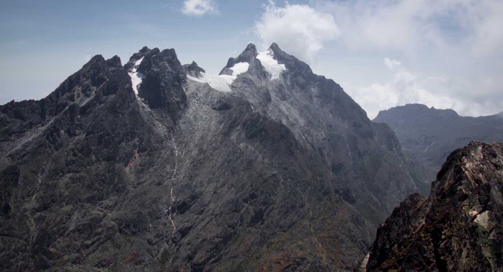
We ascend 1,146 meters to Sine Camp, situated at an elevation of 2,596 meters above sea level, where we will overnight. On the second day of our trek, we ascend to Mutinda camp at 3,588 meters, which offers a stunning perspective.
The following day, we shall trek to Bugata Camp at an elevation of 4,062 meters, via a valley abundant with wildlife, streams, and waterfalls. The trek becomes increasingly arduous at this juncture, featuring steep inclines and marshy areas to traverse.
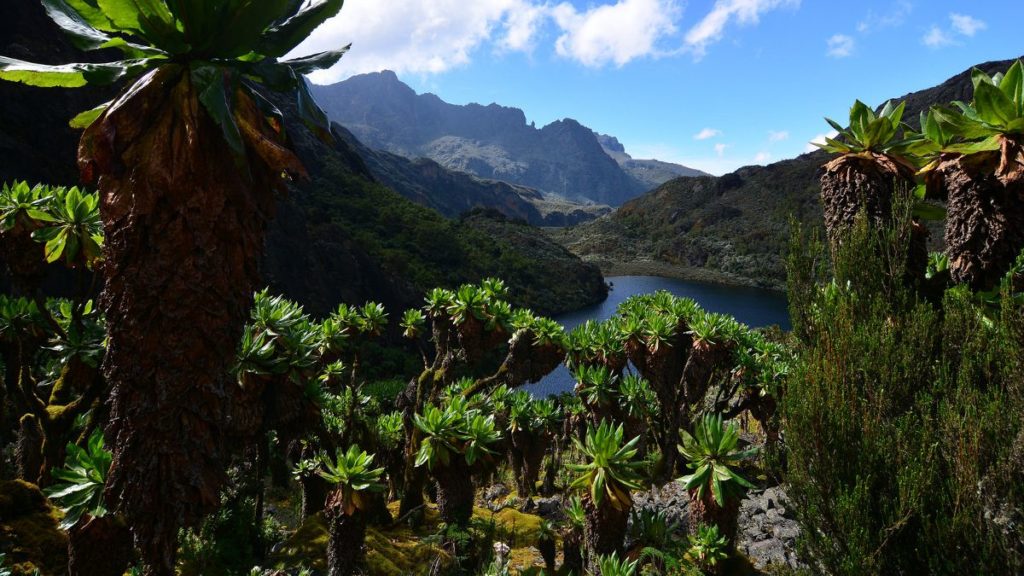
This, however, is one of the most exquisite segments of the tour. On the fourth day, we ascend to Hunwick’s Camp at 3,974 meters, over the Bamwanjara pass, which provides breathtaking vistas of the majestic snow-capped summits. Mount Baker, the imposing giant, will be observed.
Hikers depart the campsite early to go to the summit of Mount Baker (4,844m). The climb from Hunwick’s Camp to the peak requires approximately five hours, whilst the descent necessitates about three hours. You will remain at Hunwick’s Camp for an additional night. During your descent, you will go back through Bugata Camp.
What is the formation process of Mount Baker?
The mountains were produced approximately three million years ago through faulting during the late Pliocene epoch, resulting from an uplifted block of crystalline rocks, including gneiss, amphibolite, granite, and quartzite. The Rwenzori Mountains are the tallest non-volcanic, non-orogenic mountains in the world.
What is the duration required to ascend Mount Baker in Uganda?
The climb from Hunwick’s Camp to the peak requires approximately five hours, whilst the descent necessitates around three hours.
Greater summits in the Rwenzori Mountains
By 1906, snow and ice enveloped all six of the Rwenzori’s highest peaks. All except Stanley (5,109 m), Speke (4,890 m), and Baker (4,843 m) possessed snow and glaciers in 2001, although this is rapidly diminishing.
Mount Speke
Mount Speke is the second highest peak within Rwenzori Mountains National Park. Mount Baker and Mount Stanley form a triangle that encompasses the upper Bujuku Valley. Mount Stanley is situated 3.55 kilometers (2.21 miles) to the south-southwest. The mountains are situated in a region referred to as The Mountains of the Moon.
Every mountain in this range possesses multiple rugged peaks. The summits of Mount Speke comprise Vittorio Emanuele (4,890 meters), Ensonga (4,865 meters), Johnston (4,834 meters), and Trident (4,572 meters). Although the names originated from an Italian royal lineage, they required acknowledgment from the administration of the British Protectorate of Uganda, which governed the area at that time.
Upon the initial arrival of European explorers in the region, seeking the origin of the mighty Nile, this peak was named in honor of John Speke. In 1862, Speke delineated the source of the White Nile, although never ascending this peak. All mountains in this region are named after interrelated explorers who came in Africa during the initial phase of colonization. Mount Speke is traversed by numerous streams and rivers due to the substantial precipitation it experiences, and its vegetation is dense.
Mount Gessi is situated adjacent to Mount Emin in the northern region of Mount Stanley, Speke, and Mount Baker. The summit was named in honor of Romulo Gessi, an Italian explorer. The mountain, divided from Emin by a short valley in Rwenzori Mountains National Park, features twin summits known as Lolanda (15,470 ft.) and Bottego (15,418 ft.).
Gessi, at 15,018 feet (4,578 meters), is one of the six summits of the Rwenzori Mountains that form the Northern Triangle, among Mount Stanley, Baker, and Speke. Gessi is the fifth tallest mountain in Uganda, situated along a brief gorge that extends southeast from Mount Emin.
The mountains are positioned along a rocky north-south axis, with the highest peak oriented to the south. Cottages and sloped pathways on both the DR Congo and Ugandan sides of Mount Gessi delineate the route. The ascent to Gessi is a brief trail originating from Mutsori in Congo, with most indigenous tribesmen present to serve as porters and guides. A number of shanties have been preserved along the Rwenzori.
The ascent to Mount Gessi commences in Mugusu Valley and proceeds through the woodlands below to Roccato Pass, traversing dense vegetation and rocky outcrops. It subsequently leads you to the ridge that divides the two summits. The summit is said to have been formerly enveloped by glaciers that have since disappeared. Duke’s previously ascending route has deteriorated into a sequence of steep, moss-covered slabs suitable only for amateurs.
Mount Stanley
Mount Stanley, standing at an altitude of 5,109 meters (16,763 feet), is situated in Rwenzori Mountains National Park. It is the highest peak in both Uganda and Congo.
The Rwenzori Mountains encompass Mount Stanley. At an elevation of 5,109 meters, it represents the pinnacle of the Democratic Republic of the Congo and Uganda (16,763 ft). It is Africa’s third tallest peak, following Kilimanjaro (5,895 meters) and Mount Kenya (5,199 meters).
This mountain, along with numerous others in proximity, possesses sufficient elevation to sustain glaciers. This mountain is named in honor of the novelist and adventurer Sir Henry Morton Stanley. Mount Stanley constitutes a component of the UNESCO World Heritage Site known as Rwenzori Mountains National Park.
Mount Stanley features two twin summits and numerous lesser peaks. The Duke of Abruzzi, J. Petigax, J. Brocherel, and C. Ollier achieved the inaugural ascent of this mountain on June 18, 1906. Mount Stanley comprises a prominent chain of 11 summits that rise from glaciers, featuring the Stanley Plateau, the largest ice expanse in the Rwenzori Mountains, over one kilometer in length.
The summit of Margherita can be reached by trekking from the Elena hut to the initial rock formations. The route subsequently traverses the snow and ice-covered Stanley Plateau en route to Alexandra Peak, the second highest summit of the Massif.
The conventional route to Margherita Peak traverses a steep valley on the eastern face of the peak before climbing the stunning Margherita glacier to the saddle between Margherita and Alexandra summits. Proceed north to a brief, steep rock face that ascends to the peak.
A rope will be necessary for the badly crevassed glacier and the summit rocks during the ascent. Furthermore, the summit serves as a natural demarcation between Uganda and the Democratic Republic of the Congo. The eastern narrow summit of Alexandra Peak, at 4,990 meters, presents a remarkable challenge for any mountaineer.
Savoia Peak, standing at 4,977 meters, dominates a subsequent range of mountains to the south. Ascending any of the previously named summits via the renowned tropical glaciers is an indelible experience for hikers in Rwenzori summits National Park.
Mount Luigi di Savoia
Mount Luigi di Savoia is a peak in the Rwenzori Mountains National Park. The summit, “Sella,” at 4,637 feet, ranks as Uganda’s fourth highest and Africa’s sixth highest peak. Although he named it, Mount Luigi is the one peak in the Rwenzori range that the Duke of Abruzzi did not endeavor to ascend.
The Duke of Abruzzi is a renowned mountaineer who achieved the inaugural ascent of Mt. St. Elias in 1897, as well as extensive trekking on K2 in the Karakoram and nearly attaining Bride Peak on Chogolisa. The Abruzzi Rwenzori expeditions encompassed climbs to each of the Rwenzori mountains.
Mount Luigi Di Savoia is an elongated ridge featuring several peaks, namely Stairs Peak (4545 m), Sella Peak (4627 m), and Weismann Peak (4627 m). The easier approach originates from the Fresh Field Pass area, allowing ascent to the summit of Sella Peak by its northern slope. It is the shortest of the six principal mountains and the first to witness the melting of its glacial ice.
Directions to Mount Baker
Nyakalengija, the access point for the Rwenzori Mountains, is situated 22 kilometers from Kasese along the Fort Portal – Kampala Route. Park offices in Nyakalengija facilitate the payment of park fees. The Central Circle Trail and the Kilembe Way are excellent options for individuals seeking to see the region without engaging in mountainous terrain. Approximately eight days are required to finish the Central Circuit Trail.
A tour guide is necessary to explore the Rwenzori Mountains. All mountain excursions must be accompanied by a proficient mountain team, which includes a local guide, porters, and a cook, as per protocol.