
Margherita Peak
Margherita Peak, the Rwenzori Mountains constitute one of the most exhilarating mountain ranges to ascend. The immense diversity of landscapes, flora, and hiking paths is breathtaking. Margherita Peak is the pinnacle, and it is easy to overlook your location in Africa while gripping your ice axe and rope ascending 60% gradients between icicles and snow. Margherita Peak, situated on Mount Stanley in the Rwenzori Mountains, is the third highest elevation in Africa, extending from the center of Lake Albert to the north and Lake Edward to the south along the Congo-Uganda boundary. This peak, accessible in 6 to 8 days, ranks as Africa’s third tallest, following Mount Kilimanjaro and Mount Kenya.
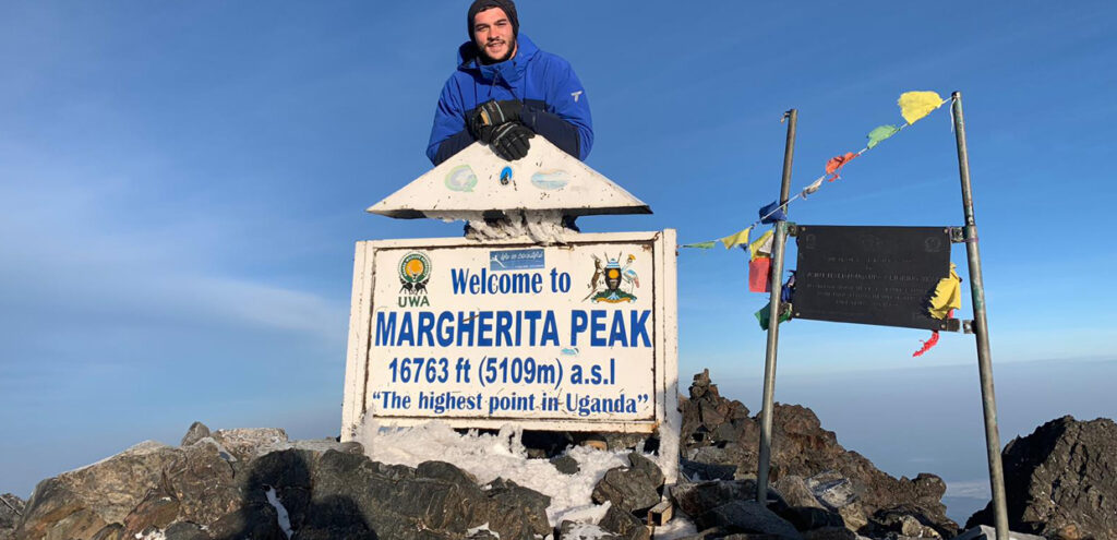
Margherita Peak in the Rwenzori Mountains is named after Queen Margherita of Italy and was first ascended by an expedition led by Luigi Amedeo Abruzzi in 1906, with the Duke of Abruzzi, J. Petigax, C. Ollier, and J. Brocherel. The Margherita peak in the Rwenzori Mountains precedes the high-altitude Rwenzori loop, which commences in the dense forests at the base and ascends above the clouds to the glacier summit of Margherita.
The ascent progresses past Africa’s extensive ice cover, surpassing the Margherita Glacier, leading to the rocky scramble to the summit of Mount Stanley, the third highest mountain in Africa’s Rwenzori ranges and Uganda’s highest peak. The well-known path traversing Elena Hut is identical to the one utilized by pioneers in the past. The glaciers in the Rwenzori Mountains are rapidly retreating due to accelerated ice melting attributed to global warming over recent decades, rendering them a noteworthy sight.
Mountain Rwenzori Trekking to Margherita Peak in a week. Yes, it is possible to reach the summit of Mountain Rwenzori Margherita Peak at 5109 meters above sea level in seven days. Margherita peak is now technical and knowledge of ropes and use of crampons, ascenders and figure 8s to belay, and knowledge of how to use an ice axe is advisable with ice sections of 60% steepness and changing rapidly due to climate change and melting of the glacier. All our guides are trained in ice climbing and rescue and can guide you up with little experience however you must be prepared to learn on the way up and to be able to fit your own crampons and at least tie basic knots and use of ascenders and figure 8s. Mt Baker and Mt. Speke are also technical we advise that clients bring their own crampons as due to the mix of hard ice and rocks we are struggling to maintain our crampons.
NOTE; Yes it is possible to climb in seven days and some clients do insist on seven days, however it should be noted that climbing more than 500 meters a day brings a bigger risk of altitude sickness, high altitude pulmonary edema or high altitude cerebral edema and all of which are dangerous. It is better to take it slower and lessen that risk and yes some people have climbed many mountains but unless you have climbed in the previous two weeks the benefits of those climbs are not there as it is the increased number of red blood cells in your blood which carry oxygen around your body. So while we can offer seven day treks we recommend the eight-day trek to be on the safer side. Altitude does not understand or recognize fitness and even though you may be super fit, altitude can still have an effect. Of course different people have different levels of tolerance to altitude but better to play safe. The cost of a seven day trek is the same as for the eight day trek so as people do not take the higher risk because of saving a few dollars and encourages them to make a decision based on their ability and fitness. Thanks for reading and understanding.
NOTE – Trekking in the Rwenzori Mountains is tough, much tougher than Kilimanjaro or Mt Kenya therefore you should be fit. The eight day trip is recommended for most people of average fitness and climbing ability however there are people who can do the trek in seven days, hence this seven day trek. But be warned you must be fit to do it in seven days. For larger groups we do not recommend seven days as in many cases there will be one person who can not keep the pace.
The Mountain Rwenzori Trekking to Margherita Peak starts at Trekkers Hostel in Kyanjuki, Kilembe which is situated 1,450 meters above sea level and 12 kilometers from Kasese town. It is best to start the trek by 9 am but you can leave as late as 11am. You walk 2.2km to the UWA rangers post at 1,727 meters, which takes about one hour. Here you pay the gate entrance fee and the rangers brief you on the rules of the National Park.
The comprehensive schedule for the Mountain Rwenzori Trek to Margherita Peak
Day 1: Trek to Kalalama Camp at an elevation of 3134 meters.
We commence by traversing the valley floor amidst the towering trees of the Afro Montane Forest Zone. This is a gradual ascent featuring numerous birds and the possibility of observing blue monkeys darting across the forest. Occasionally, visitors may observe groups of 15 to 20 black and white Colobus monkeys as they traverse the treetops. Rare sightings of the L’Hoest monkey, integral to Bukonzo cultural icons, are safeguarded by the authority of the King or Omusinga, although distant sounds of wild chimpanzees may also be heard. Upon entering the Bamboo-Mimulopsis Zone, one encounters a diverse array of plant species, ranging from forest trees to bamboo thickets, amidst a steep ascent characterized by several high stairs. During the wet season, the bamboo zone becomes quite muddy and slippery, resulting in slow progress; yet, it is manageable for those in good physical condition. The environment and forest are exceptional as you ascend to Kalalama Camp at 3,147 meters, situated in the Heather-Rapanea Zone, characterized by numerous tall heather trees and ample opportunities to observe the Rwenzori Turaco (Gallirex johnstoni) from the family Turacos (Musophagidae), distinguished by its vibrant crimson wings.
Day 2: Trek to Bugata Camp at 4100 meters
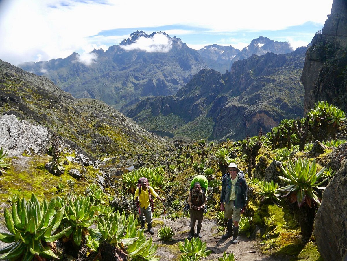
Following an early breakfast, you go to circumvent Mutinda Camp and proceed to Bugata Camp at an elevation of 4,100 meters. The trail winds over several small knolls along a ridge, descends into the valley, ascends once more, traverses multiple small streams, and approaches moss-covered waterfalls. You ascend gradually alongside a picturesque moss-covered river cascading over rocks beneath the Giant Heather trees, whose trunks are adorned with green moss and Usnea lichen draping from the branches. The path winds as you ascend the profound valley, which has a vast array of flora and blossoms. This valley is distinctive, with several Giant Heather trees that cultivate a picturesque ambiance frequently enveloped in mist. The path is marshy, especially during the rainy season; yet, with some adeptness, one can traverse from tussock to tussock to facilitate movement. We have constructed multiple boardwalks over the most challenging bogs and are continuing to build additional ones to facilitate access. You traverse the Mutinda Valley, navigating through tussock grass and everlasting flowers intermingled with several Giant Lobelias, before ascending a steep incline to the Namusangi Valley (3,840 meters), which culminates abruptly in spectacular waterfalls and breathtaking vistas of the Mutinda Peaks. The Namusangi Valley is expansive, characterized by several elevations and depressions, while traversing multiple marshes as the path ascends consistently to Bugata Camp at 4,062 meters. Bugata Camp is located at an elevated position on Bamwanjara Pass, overlooking Bugata Lake, with vistas of Lake Kopello and Weismann’s Peak, frequently adorned with snow, as well as views down the valley of Lake Africa, Lake Kanganyika, and the numerous minor peaks leading to Mutinda Camp. The region is populated with tussock grass, everlasting flowers (Helichrysum), St John’s Wort (Hypericum becquaeritii), gigantic groundsel (Senecio adnivalis), and giant lobelia (Lobelia gibberoa). A significant population of Red Forest Duikers (Cephalophus nigrifrons rubidus), a subspecies exclusive to the Rwenzori Mountains, exists.
Bugata Camp has commendable facilities, including solar lighting, well-maintained toilets, and bathrooms where guides can provide warm water in a basin for your washing needs. Bugata is equipped with a helicopter pad (GPS coordinates N 18.312 E 29 53.457) for potential rescue operations; nevertheless, it is important to note that helicopter services in Uganda are over $10,000 per hour, much exceeding rates in other nations, necessitating insurance for rescue scenarios.
Day 3: Ascend to Hunwick’s at 3974 meters.
Journey to Hunwick’s Camp through Bamwanjarra Pass. Upon departing Bugata Camp, you ascend a ridge, thereafter descend slightly, and then climb to Bamwanjarra Pass at 4,450 meters, where a hut is available in case of inclement weather. On a clear day, the pass offers superb vistas of the three principal peaks. The trail traverses the valley, skirting the periphery of bogs and dense evergreen flora, including moss, gigantic groundsel, and lobelia. This location may be the premier site in the Rwenzori for observing the Malicite Sunbird since it forages on numerous lobelia flowers and serves as a recognized breeding ground. Further down, there are steep sections followed by a consistent ascent over a ridge to Hunwick’s Camp, located atop a deep valley, with excellent views of Mt. Stanley, Mt. Baker, Weismann’s Peak, and McConnell’s Prong.
Day 4: Hike to Margherita Peak at 4,485 meters.
We traverse from Hunwick’s down to the valley bottom, reaching the breathtaking Lake Kitendara, characterized by its profound waters and exquisite flora. From this point, ascend Scott Elliott’s pass and continue along the ridge to Margherita Camp, located at an elevation of 4,485 meters, nestled among substantial boulders that provide some protection from the fierce winds. This is the precise location where the Duke of Abruzzi established his camp during his ascent to Margherita Peak in 1906.
Day 5. Hike to Margherita Peak at 5,109 meters.
Awaken at 2:00 AM and partake in an early breakfast before to departing for the ascent of Mt. Stanley at 2:30 AM. This is essential due to significant weather fluctuations; even during the dry season, the mountain frequently becomes enveloped in dense clouds, with snowfall occurring between 1 PM and 4 PM, often within a brief interval of 10 to 15 minutes as clouds ascend from the vast Congo jungles. In January and February 2017, clients were confined indoors and unable to traverse due to unprecedented severe snowstorms, which had not been experienced during the drier season. They returned to Margherita Camp well after dark, with one party arriving around 11 PM, completely fatigued. In light of the weather change, we have established a turnaround time of 10 AM. If you do not reach the summit by that time, you must return, irrespective of any disappointment, for safety reasons. The Margherita Glacier has been adversely affected by global warming, resulting in the recession of its outer margins and an increase in the steepness of the ice, with one portion exceeding a 60% slope across a span of approximately 200 meters. The extensive melting of the darker material beneath has resulted in the formation of caves under the ice, which, as it thins, may ultimately collapse. It is essential for clients to comprehend and heed the recommendations of the advisors regarding the suggested routes.
We recommend that clients with limited mountaineering skills remain on Stanley Glacier and ascend to a prominent vantage point on a granite outcrop at the southern side of Alexandra Peak to appreciate the spectacular views of Congo and the lower mountain ridges.
Upon reaching the summit at 5,109 meters, you subsequently descend directly to Hunwick’s Camp at 3,874 meters.
Day 6. Descend to Kiharo Camp at 3640 meters.
Distance to Kiharo Camp: 11 kilometers Duration required for walking is between 4 to 7 hours.
We commence the day at Hunwick’s Camp by ascending a ridge towards McConnell’s Prong, which offers the finest vistas of all three summits and Scott Elliott’s Pass, before arriving at Oliver’s Pass at an elevation of 4,505 metres. The distance from Hunwick’s Camp to the summit of Olivers Pass is 3 kilometers. The trail subsequently traverses beneath Weismann’s Peak to the junction of the Nyamwamba River, which descends through Kilembe and Kasese to Lake George in Queen Elizabeth National Park.
To ascend Weismanns Peak, which stands at 4,620 meters from Olivers Pass, an additional fee of $20 per person is required. On a clear day, one can observe magnificent vistas of Margherita, Mt Stanley, Mt Speke, and Mt Baker.
Upon traversing the confluence, the trail descends into the valley leading to Kiharo Camp, located within a profound valley characterized by towering cliffs and lush foliage. As you descend the valley, after each bog, you will ascend a ridge of stones and soil that appears incongruous; nonetheless, it was deposited by slowly advancing glaciers that ultimately ceased their movement, melted, and left a mound of rocks and debris at the location where the glacier formerly existed.
Day 7. Descend to the base camp at 1450 meters.
The distance from Kiharo Camp to the park gate is 12.2 km, followed by a further 2.8 km to Trekkers Hostel. Individuals requiring connections to flights back to Kampala or proceeding to other engagements must depart from Kiharo early, as the journey necessitates 5 to 8 hours of walking.
The descent through the Nyamwamba Valley is predominantly downhill and exceptionally picturesque, featuring magnificent vistas, moss-laden rocks adjacent to the river, flowing waterfalls, and profound gorges and woods, maybe the finest in the Rwenzori Mountains. This segment of the path required six years to provide a navigable route suitable for travelers. In 1937, the explorer and geologist McConnell attempted to navigate this valley but was unsuccessful and had to retreat in search of an alternative route up the mountain; nonetheless, you can now witness this remarkably magnificent valley.
A few kilometers from Kiharo Camp, the trail diverges to the right to follow the river. In the open regions, one may observe a Duiker discreetly foraging in small clearings while traversing the riverbank. If desired, one may choose to traverse the river by jumping across the rocks along its course. A few kilometers downstream, the terrain becomes exceedingly steep with numerous waterfalls, necessitating a diversion from the river to traverse a short ridge in order to circumvent the steep areas. At the base, we encounter the river once more, featuring a substantial rock shelter and a suitable area for repose. Upon traversing a minor creek, you ascend a gradual incline before descending towards the river to circumvent another series of insurmountable waterfalls. The forest in this area is spectacular and teeming with wildlife, including numerous birds, primates, duikers, and hyraxes. An exceptional experience and conclusion to a remarkable adventure.