
Mount Stanley
Mount Stanley is the tallest summit of the Rwenzori Mountains. The mountain ranges delineate the borders of Uganda and the Democratic Republic of the Congo. This magnificent mountain ascends through jungle and unusual wetlands to a succession of serrated peaks encircled by Africa’s largest aggregation of glaciers. Mount Stanley is a fault-block peak located inside the African Rift System, positioned between two rifts.
They consist of gneiss and quartzite and were formed within the past 10 million years. The mountains are frequently enveloped in fog and rain, accompanied by regular thunderstorms and lightning.
No other location on Earth possesses such an extraordinary variety of bogs, mosses, and forests reminiscent of those depicted in The Lord of the Rings. Intense precipitation, including rain, sleet, and snow, affects the range for a significant portion of the year. The two arid periods are January-February and June-August. It is highly recommended that you arrange your travel for one of those periods. Nevertheless, extended periods of fog and precipitation are feasible. Fortunately, the precipitation was often mild and lasted only a few hours.
Directions to Mount Stanley
At present, Uganda represents the most economical route to access Mount Stanley. Entebbe Airport, situated on the shores of Lake Victoria, offers efficient service with regular flights to Nairobi and Kigali. Entebbe and Kampala host a multitude of hotels, both situated within thirty minutes’ drive from the airport. Two primary routes lead from Kampala to the Rwenzori Mountains. One traverses the charming town of Fort Portal en route to Kasese. An alternative route traverses Masaka, Mbarara, and proceeds to Kasese. The route is paved with tarmac until around a few kilometers from the mountain’s foot.
For independent adventurers, public transportation options including as buses or taxis are available from Kampala to Kasese. Engage a local taxi to transport you to the mountain’s base. You may opt to hire a self-drive vehicle and navigate to the peak independently. We can organize and implement your safari according to your specifications.
Historically, activities in the Rwenzori Mountains have been focused on a circuit that ascends the Bujuku Valley, over the Scott Elliot Pass to the picturesque Kitandara Lakes, and then crosses Freshfield Pass into the Mubuku Valley. The primary circuit features an excellent network of shelters and pathways. The trails are occasionally uneven, featuring heavy mud in several areas.
Efforts have been undertaken at different times to construct boardwalks over certain deeper bogs. Rwenzori Mountaineering Services provides safaris to Mount Stanley and consistently maintains these wooden boardwalks. The majority of individuals require approximately one week to ascend Mount Stanley. This is an example of a standard travel itinerary:
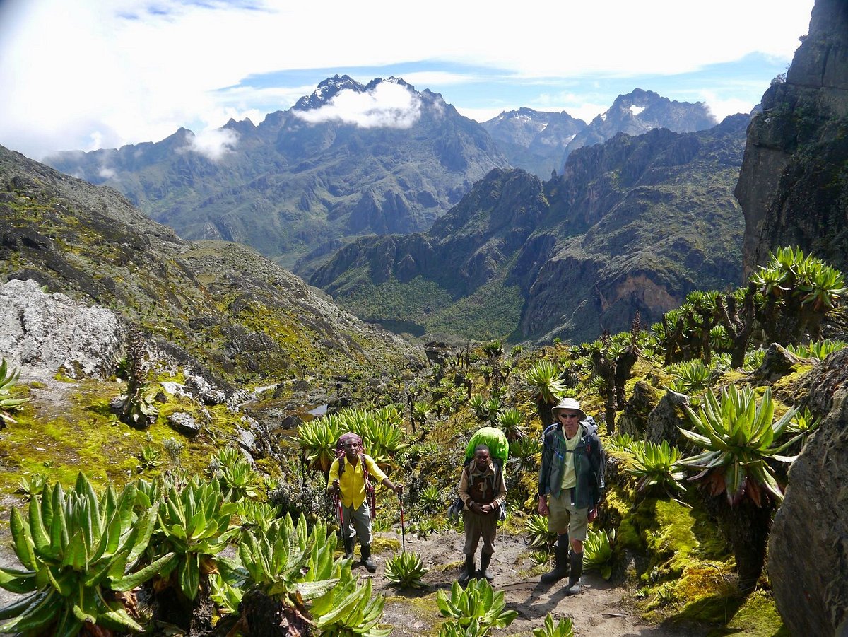
Day 1: Depart from Kasese town and advance along the road to the Nyakalengija gate. Proceed along the Mubuku River, traversing verdant jungle and navigating through thickets where sporadic sightings of elephants and chimpanzees may occur. This marks the commencement of a steep glacier moraine. This trail traverses large ferns to the Nyabitaba hut at an elevation of 2600 meters, where chimpanzees and monkeys may be heard or observed. The majority of hikers necessitate approximately 5 hours to reach 1200 meters. The Portal Peaks are seen from the resort.
Day 2: Descend from the moraine to traverse the Mubuku River, then ascend to the John Matte Hut at 3500 m, surrounded by bamboo and trees adorned with moss and ferns. On this specific day, the path is very arduous. This hike is approximately seven hours in duration.
Day 3: Traverse the Lower Bigo Bog from the John Matte shelter to the older Bigo hut. A one-day or multi-day expedition to the Mugusu Valley, leading to Lac de la Lune, the source of Ptolemy’s Nile, is now feasible. Mount Gessi and Mount Emin can also be accessed through this valley. By remaining on the primary trail, you will traverse breathtaking landscapes, including the Upper Bigo Bog and Lake Bujuku, ultimately reaching the Bujuku Hut at an elevation of 4,075 meters. Numerous folks allocate 5 hours to ascend 560 meters. Mt. Stanley is visible from this location if the weather permits. The Bujuku Hut serves as the primary departure point for ascending Mt. Speke. Certain swift hikers do the approach and summit ascent inside a one day.
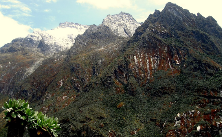
Day 4: Ascend to the Elena Hut at 4540 meters, formerly situated adjacent to the Elena Glacier. The arduous climb requires several hours to finish. One segment of the expedition is ascending an extensive ladder (Groundsel Gully). The upper section of the climb consists of moss-laden slabs. The vista from the hut is typically obscured by fog; however, when the weather improves, it can be breathtaking, revealing the Portal Peaks and Mt. Baker, along with a remarkable sight of the Coronation Glacier on Mt. Stanley. In some aspects, traversing ice-laden ledges from the cabin to the outhouse during the early morning hours can constitute the most challenging segment of the ascent.
Day 5: Ascend steep, often damp slabs to reach the Elena Glacier and Africa’s largest ice field, the Stanley Plateau. Depending on the situation, one of several options may be employed. The exceptional southeast ridge of Alexandra Peak is readily accessible from this location. Traversing the Stanley Plateau to the north allows access to the apex of Alexandra’s SE Ridge, from whence one can descend a steep gully to the Margherita Glacier, ascend to the Alexandra/Margherita Col, and thereafter advance to the summit of Margherita Peak on snow trending left, followed by often wet or icy rock.
The Margherita glacier is fraught with crevasses, numerous of which are concealed beneath a delicate coating of snow. Moreover, wild ice formations are often seen along the roadway and on adjacent ridges. To access the Democratic Republic of the Congo, utilize the route located to the west of the sign at the summit. Continuing west along the ridge to attain Albert Peak is also conceivable. Proceed back to the Elena cabin and descend towards the picturesque Kitandara Lakes. A substantial area in the valley below has been devoid of all vegetation.
Day 6: Ascend Freshfield Pass (300 meters height gain), followed by a descent to Guy Yeoman Hut (3500 m). Mt. Baker and Mt. Liugi Di Savoia are accessible for climbing from the vicinity of the pass. The flora is remarkable. During your descent, you see an antiquated campsite of the Duke of Abruzzi (Bujongolo), adorned with graffiti from early twentieth-century expeditions. A location as exquisite in its own merit as any on Earth.
What is the significance of Mount Stanley?
Mount Stanley holds significance for various reasons. Mount Stanley hosts significant biodiversity and numerous endangered species, rendering it a vital conservation area. Secondly, Mount Stanley serves as a significant water source for the adjacent settlements. Tourists and adventurers globally are drawn to Mount Stanley because to its stunning beauty and distinctive trekking chances.
What is the formation process of Mount Stanley?
Mount Stanley ascends between two fissures in the African Rift System. The gneiss and quartzite constituting these mountains were produced within the past 10 million years. The mountains are perpetually enveloped in fog, precipitation, and thunder. The range experiences substantial precipitation, including rain, sleet, and snow during the majority of the year, with two drier intervals occurring between January and February, as well as between mid-June and mid-August. It is strongly advised to schedule your vacation within one of those intervals.