Facts About Virunga Mountains
The Virunga Mountains comprise eight renowned volcanic peaks located in the Albertine region. The Virunga Mountains are locally referred to as the Birunga Mountains or the Mufumbiro Mountains, named for the smoke emitted by the active volcanic peaks. Mufumbiro, in the native dialect of the region, signifies kitchen or cooking, hence the moniker. The Virunga Mountains extend 80 kilometers along the borders of Uganda, Rwanda, and the Democratic Republic of Congo.
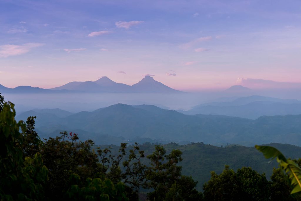
The mountains extend from the east to the west at a right angle to the Albertine Rift Valley, which also encompasses Lake Kivu and Lake Edward. This rift valley extends 4,000 miles from the Gulf of Aqaba across the Red Sea to the Ethiopian highlands. The Virunga Mountains comprise eight peaks: Mount Karisimbi, Mount Mikeno, Mount Muhabura, Mount Bisoke, Mount Sabinyo, Mount Gahinga, Mount Nyiragongo, and Mount Nyamulagira. Mount Karisimbi is the tallest peak in this range, reaching an elevation of 14,787 feet (about 4,507 meters), while the lowest is the highly active Mount Nyamulagira, standing at 10,031 feet (roughly 3,058 meters).
All eight aforementioned volcanoes have exhibited volcanic activity in recent years; however, only two are presently active. Mount Nyamulagira and Mount Nyiragongo are the two volcanoes in the Virunga range currently exhibiting eruptions, with the most recent eruption being at Mount Nyiragongo in May 2021. Mount Nyiragongo and Mount Nyamulagira are regarded as the two most active volcanoes in the region, accounting for 40% of the volcanic activity in Africa.
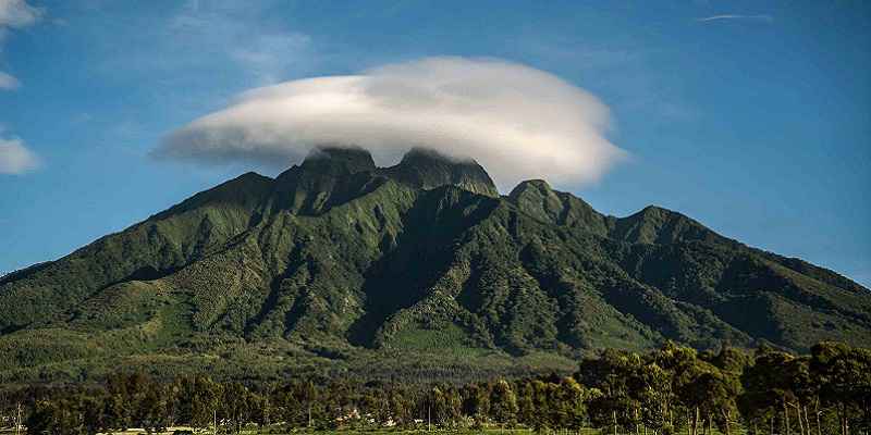
The remaining six volcanoes are presently classified as dormant due to the absence of volcanic activity for many years. Mount Mikeno and Mount Sabinyo are the oldest of the Virunga Mountains, believed to have existed approximately 2.6 million years ago. Their lava crater lakes have remained devoid of water, and the elements have significantly eroded the peaks.
Mount Karisimbi, the tallest mountain in the Virunga range, along with Mount Bisoke, Mount Gahinga, and Mount Muhavura, features a summit crater, but Karisimbi is distinct in lacking a summit crater. The summit of Muhabura features a crater lake accessible via a hiking trail. Mount Nyiragongo and Mount Nyiragongo developed approximately 20,000 years ago, with lava crater lakes at their summits.
The summit crater of Mount Nyiragongo is the largest lava crater lake globally, measuring around 2 kilometers in diameter, with an indeterminate depth that fluctuates with each volcanic eruption. The inaugural documented eruption of Mount Nyiragongo occurred in 1912, followed by several eruptions in the 1970s and in 2002, with the most recent recorded eruption in 2021, which has resulted in the lake being depleted and raised concerns about potential dormancy; nonetheless, it remains premature to draw definitive conclusions on this matter.
The volcanic eruptions of Mount Nyiragongo have devastated property in Goma and resulted in fatalities among the local population, leaving many individuals homeless. A journey through Goma provides an intimate perspective on the impact of the Nyiragongo volcano.
The Virunga Mountains were initially observed by British explorer John Hannington Speke, who sighted the ranges from afar in 1861, while another British explorer, Sir Henry Morton Stanley, examined many of these volcanoes more closely. The inhabitants of Rwanda, Uganda, and the Democratic Republic of Congo residing near and on the slopes of these mountains recognized them due to the fertile soils that enhance their agricultural endeavors.
Three national parks offer opportunities to hike volcanoes: Virunga National Park in the Democratic Republic of Congo for an overnight ascent of Mount Nyiragongo; Mgahinga Gorilla National Park in Uganda for hikes to Mgahinga and Mount Muhabura, culminating at the crater lake; and Volcanoes National Park in Rwanda for an overnight trek up Mount Karisimbi or hikes to Muhabura, Bisoke, or Gahinga.
The area including the Virunga Mountains is referred to as the Albertine zone and is the second location where endangered mountain gorillas can be walked. The mountain gorillas are renowned for trekking in Uganda’s Bwindi Impenetrable National Park.
The Virunga Mountains: Virunga Volcanoes comprise a series of around eight volcanoes. They are situated in the East African Rift Valley, and it is alleged that they are part of this Rift.
The term “ibirunga,” originating from the Kinyarwanda dialect, literally translates to “Mountains,” from which the word Virunga is derived.
The Virunga region, as previously mentioned, has eight volcanoes situated between Lake Kivu and Lake Edward. The mountains comprise: Mount Nyamurangira (3058 meters), Mount Nyiragongo (3470 meters), Mount Gahinga (3470 meters), Mount Bisoke (3711 meters), Mount Sabyinyo (3611 meters), Mount Muhabura (4127 meters), Mount Mikeno (4437 meters), and the highest peak, Mount Karisimbi (4507 meters).
These volcanoes also provide as habitat for the endangered mountain gorillas. Volcanoes National Park has 5 of the 8 volcanoes. Three of these volcanoes remain active, while the others are dormant.
Most of these mountains exhibit a conical shape in contrast to typical mountains. The names of these mountains are derived from their geological qualities; for instance, Sabyinyo translates to “the old man’s teeth,” as their appearance resembles that of an elderly man’s teeth.
Numerous recreational activities are available for participation. These mountains are indeed accessible for hiking. Mountain gorillas inhabit the slopes of these mountains. You can visit the local populations that inhabit the slopes of the mountains, many of which have been resettled outside these areas, such as the Batwa people.